Impact of Oil Spill on the Inhabitants of Bodo Area of Ogoni Land, River State, Nigeria
-
Odera Chukwumaijem Okafor


Department of Geography, Faculty of Environmental Sciences, Alex Ekwueme Federal University Ndufu-Alike, Ikwo, P.M.B. 1010, Ebonyi State, Nigeria
Patience Afor IbenemeDepartment of Geography, Faculty of Environmental Sciences, Alex Ekwueme Federal University Ndufu-Alike, Ikwo, P.M.B. 1010, Ebonyi State, Nigeria
| Received 25 Mar, 2025 |
Accepted 23 May, 2025 |
Published 30 Jun, 2025 |
Background and Objective: Due to the serious problem of oil spillage, especially the oil spill of 2008, many of the inhabitants were rendered jobless and homeless, and it even impacted their health. The aim of this work, therefore, was to assess the impacts of the oil spill on the inhabitants of the Bodo Area of Ogoni Land in Rivers State, Nigeria. Materials and Methods: Satellite imagery over the area was sourced from NASRDA (NigeriaSat-1, 2007, and NigeriaSat-x, 2012), taken before and after the spills, respectively. These images were analyzed to determine the effect of the oil spill on land cover changes, particularly the mangrove, and to ascertain the changes that took place before and after the oil spill. Erdas 9.2 software was used for the image’s unsupervised classification, which was later moved to ArcMap for image layout view. Questionnaires were administered to extract information based on the impact of the oil spill as it affected the inhabitants of the area. Results: There are changes in land cover in terms of vegetation cover, bare land/grassland, water bodies, and developed areas. The results also show that the oil spill has negative impacts on the environment and socio-economic life of the inhabitants of the area, such as the death of aquatic life, freshwater contamination, loss of jobs and livelihoods, and environmental degradation. Conclusion: A thorough Environmental Impact Assessment (E.I.A.) should be conducted before oil exploration and exploitation in oil-rich regions (Bodo Area inclusive); there should be immediate dispersal of information concerning spillages and immediate cleanup and compensation of the affected people, as the case may be. Finally, GIS should be used to identify areas of spill coverage and provide information about the closest resources for oil spill response equipment and personnel.
| Copyright © 2025 Okafor and Ibeneme. This is an open-access article distributed under the Creative Commons Attribution License, which permits unrestricted use, distribution, and reproduction in any medium, provided the original work is properly cited. |
INTRODUCTION
Water is an essential element for the survival, development, and reproduction of aquatic life. It also facilitates the movement of fishing vessels and trawls, serving the needs of both small-scale fish farmers and industrial fishers. Research indicates that water is a fundamental part of the dynamic aquatic ecosystem, enabling the dissolution or suspension of both organic and inorganic materials, and fostering interactions among diverse organisms1. Additionally, water bodies provide various ecosystem services, including water supply, production, recreational opportunities, and aesthetic value2. The quality and quantity of available water are crucial for health maintenance; however, human activities often lead to the degradation of surface water. Studies have identified hydrology, physico-chemical parameters, and biological communities as the three key components in assessing water quality2. Their report indicates that the quality of sediment and interstitial water is closely related to the varying conditions of the overlying water column. This relationship is influenced by both bottom-up and top-down fluxes between the ecological parameters of these two components, which are contingent upon the surrounding environmental conditions. As noted, the physicochemical and biological factors play a crucial role in determining the quality of any water body, as there exists an interactive relationship among these factors and intrinsic characteristics of each variable that significantly influence water quality attributes3. The quality of water has a direct impact on the composition, distribution, and assemblages of plankton, benthos, and fish species. In developing countries, including Nigeria, water body pollution has reached a critical level.
Numerous studies have addressed the physicochemical parameters of surface water in Nigeria4. It has been reported that water bodies are subjected to various forms of degradation due to pollution from domestic waste, industrial activities, and runoff from agricultural and transportation operations5. They emphasized that transportation activities have recently been linked to rising levels of environmental impact. Their research indicated that utilizing waterways for inland navigation could threaten aquatic life and significantly affect water bodies. These effects encompass alterations in hydrological conditions, degradation of water quality, and the emission of pollutants. Additionally, they noted a growing demand for water transport, which has led to spills of chemical substances, particularly oil, nutrient overload, and the introduction of invasive species, all of which are critical factors affecting water quality. The waste generated from water transportation includes sewage, gray water, bilge water, gas emissions, and both solid and hazardous waste, with metals, mineral oils, lubricants, and organic materials being the primary components. For more than fifty years, the exploration and extraction of crude oil have played a pivotal role in Nigeria’s economy. The Niger Delta region, known for its substantial oil and natural gas reserves, is estimated to contain 37.4 billion barrels of oil and 192 trillion standard cubic feet of natural gas6. The first significant discovery of crude oil in Nigeria occurred in Oloibiri, Bayelsa State, in 19567,8. Two decades later, in 1976, a second discovery of crude oil in commercial quantities was made at the Bomu oil field in Ogoni, Rivers State. This later find significantly contributed to Nigeria’s inaugural oil exports to international markets. The operations in Ogoni expanded to include fifty-seven oil wells and five flow stations, one of which is the Bodo West field situated in the mangrove area of Bodo Creek, Ogoni9-11. In 2008, Bodo Creek experienced two major oil spills, primarily attributed to the activities of multinational oil companies12. Additionally, oil spills resulting from artisanal crude oil refining have posed a serious environmental challenge in Bodo Creek.
Another study by Frynas13 indicates that artisanal refining refers to the unauthorized distillation of crude oil using locally built stills. This practice has significantly increased environmental pollution and degradation linked to oil exploration and extraction. The research also highlights that artisanal refineries are typically located along the coastlines of creeks, lakes, and seas, resulting in the destruction of biodiversity and contributing to ecological imbalance. In Bodo West, within the Bonny Local Government Area, the rise in artisanal refining from 2007 to 2011 has led to a 10% reduction in healthy mangrove cover, equating to 307,381 square meters. Crude oil is discharged into the sea and creeks during various stages, including bunkering, transportation to the site, and the refining process itself. Bunkered oil is often transported by canoe, which frequently experiences leaks, allowing oil to seep into the river. Furthermore, the research identifies that the primary source of hydrocarbon contamination from artisanal refining stems from the accidental disposal of crude oil, refined products, and the careless storage of heavier fractions resulting from the petroleum refining process.
Heavier fractions, such as bitumen and lubricating oil, are not suitable for processing by existing refinery facilities. Consequently, these materials are typically either stored or disposed of in pits located near refining facilities. Research indicates that this method is highly inefficient, with estimates suggesting that up to 80% of the lower fractions of crude oil remain unrefined and are consequently released into the environment without proper management. These substances can eventually be carried into the sea, rivers, or lakes during high tides, settling on the shoreline and seabed14. Over the years, the Niger Delta has witnessed numerous oil spill incidents. Reports indicate that oil pollution can lead to catastrophic outcomes, and Nigeria has faced several disasters due to oil blowouts, in addition to pollution from various other sources15. Notable incidents include the blowouts at Shell-BP Bomu 11 in 1970, the Safran (now Elf) Obagi 21 blowout in 1972, the Texaco blowout in 1980, and the Agip Oyakama pipeline leakage in 1980, all of which have had severe repercussions on land, freshwater swamps, and marine ecosystems. On a global scale, significant oil spill incidents have been documented, ranging from the largest recorded spill, the Persian Gulf War Oil Spill in 1991, to BP’s Deepwater Horizon spill in 2010. Significant oil spills in history include the Ixtoc 1 Oil Spill (1979), the Atlantic Empress Oil Spill (1979), the Mingbulak (or Fergana Valley) Oil Spill (1992), the Kolva River Spill (1994), incidents at the Nowruz Oil Field, the Castillo de Bellver Oil Spill (1983), and the Amoco Cadiz Oil Spill (1978). These spills can severely affect the stability of both freshwater and marine ecosystems, with documented adverse effects on near-shore biodiversity16 and ecological functions17,18.
In Nigeria’s Niger Delta, known as the country’s oil and gas hub, oil spills occur frequently, and their effects are exacerbated by inadequate clean-up and remediation efforts19,20. Research indicates that contamination from oil spills can disrupt hydrology, interfere with plant-water interactions, diminish oxygen exchange, inhibit growth, reduce fish production, and disturb the ecological food chain and food web21,22. Hence, this study was undertaken to assess the effect of the oil spill on land cover changes and examine the impact of the oil spill as it affects the inhabitants of Bodo. The objectives of the present research, therefore, are to assess the effect of the oil spill on land cover changes and to examine the impacts of the oil spill as it affects the inhabitants of Bodo.
MATERIALS AND METHODS
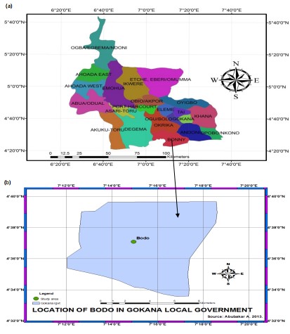
Study area: Bodo Community lies on the coastal lowland of the Niger Delta, in the Southern part of Gokana Local Government Area of Rivers State (Fig. 1a and b). The community is about 56 kilometers by road from Port Harcourt, the capital of Rivers State, and is located between Latitude 4°37'29"N and Longitude 7°16'3"E of the equator, with an elevation of approximately 140 m. According to the 2006 National Population Census figures, Bodo City and its surrounding villages have a population of about 49,000 people23. The majority of the population of Bodo traditionally depends on subsistence fishing and farming as a means of livelihood. Total annual rainfall decreases from about 4,700 mm on the coast to about 1,700 mm inland. The mean monthly temperature ranges from 25 to 28°C. The mean annual temperature for the state is 26°C. The hottest months are from February to May. The “upland” area was originally covered by rainforest, which has been drastically modified by human activities. In most places, economic trees, particularly oil palm, have been preserved, earning this vegetation the sobriquet “oil palm bush”. The riverine area is divisible into three main hydro-vegetation zones, namely the beach ridge zone, the saltwater zone, and the freshwater zone24.
Satellite imagery of the affected areas was collected from NASDRA (National Space Development and Research Agency), which was acquired from NigeriaSat-1 and NigeriaSat-X in 2019 and 2023, respectively, and taken before and after the spill. The acquired images were processed using Erdas 9.3 and ArcMap 9.1 software. Erdas was used for unsupervised classification, which was later imported to ArcMap for layout view in terms of map formation and geo-referencing. The land-use and land-cover images helped to assess the land-cover changes in terms of vegetation, bare land, and developed areas, as well as oil spill records from libraries and internet documents. Questionnaires were administered, and a personal interview was held with the Director of the National Oil Spill Detection and Response Agency (NOSDRA), who is the National Focal Point and the coordinating agency for oil detection and response in Nigeria. Finally, personal observation was useful to complement the other data collection instruments (personal interview and questionnaire).
|
Sampling technique and size: The methodology adopted for administering all the questionnaires in the entire study area is simple random sampling by making transect walks ranging from 50 to 100 m and 100 to 200 m, depending on the proximity of buildings. However, consideration was given to areas closest to the spill sites.
Data presentation and analysis: The data collected were presented using maps, satellite images, tables, graphs, and charts. Individual analyses of the data were made based on the derived data. The data collected were subjected to a largely descriptive analysis, using a simple statistical analysis of each characteristic found in the material, as well as using a pie chart and graphs for analysis. The information collected was transcribed and translated into subsections and utilized inductive reasoning as well as content analysis to ascertain the extent of impact.
Chi-square method: The statistical analysis method used for this study is the Chi-square method. A Chi-square test (also Chi-squared or χ2 test) is the test commonly used to compare the observed data from any study or investigation with the expected data24.
|
The first step in the Chi-square test is to calculate the Chi-square statistic. To avoid ambiguity, the value of the test statistic is denoted by χ2 (i.e., uppercase chi instead of lowercase); this also serves as a reminder that the distribution of the test statistic is not exactly that of a Chi-square random variable. The Chi-square statistic is calculated by finding the difference between each observed and theoretical frequency for each possible outcome, squaring them, dividing each by the theoretical frequency, and taking the sum of the results. A second important part of determining the test statistic is to define the degrees of freedom of the test: this is essentially the number of observed frequencies adjusted for the effect of using some of those observations to define the theoretical frequencies.
Calculating the test-statistic: The value of the test-statistic is22:
Where:
| Χ2 | = | Test statistic that asymptotically approaches a χ2 distribution | |
| Oi | = | Observed frequency | |
| Ei | = | Expected (theoretical) frequency, asserted by the null hypothesis | |
| N | = | Number of possible outcomes of each event |
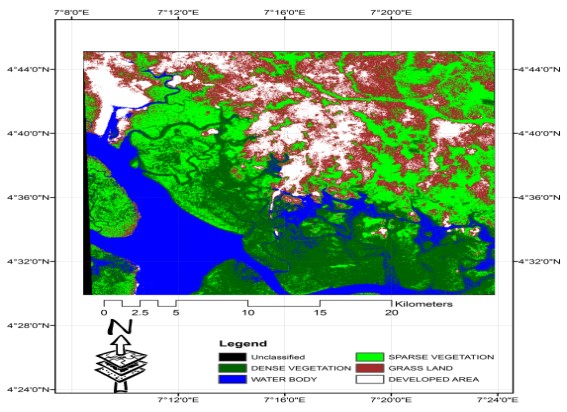
In Fig. 2, farmlands and grass/bare land are visible along the banks in the western part of the image, hence depicting human activities along the riverbank.
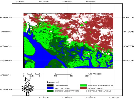
In Fig. 3, due to the oil spill that affected the farming and fishing activities of the inhabitants, the sparse vegetation in the eastern part has disappeared, leaving the area bare and allowing many human activities to take place in such areas, such as business centers, settlements, schools, and subsistence farming, etc.
|
RESULTS AND DISCUSSION
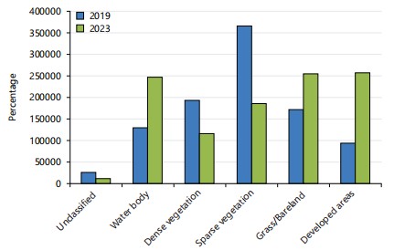
A summary of the results regarding the assessment of land cover changes, as contained in Fig. 4, is that the dense vegetation in 2019 was greater than in 2023. This is attributed to the oil spill, which affected the vegetation in the environment, especially at the water bank, leading to the death and destruction of the vegetation. The result of this work is also aligned with the work of Mezgebe et al.3, who noted that Ogoni land has alluvial and arable land suitable for a variety of agricultural ventures. The people of Ogoni used to be predominantly farmers and fisherfolk, though some engaged in trading, crafts, and civil service. This has changed over a five-decade period, following multiple oil spills that have polluted the land and destroyed its vegetation. Nkeeh et al.4 stated that the land in Ogoni land was once used for the cultivation of cassava and cocoyam, but now it can no longer be cultivated. Alame et al.8 said that the area, before the havoc done by the oil spill, was the sacred land of the Bodo people; it is an area where almost all the water that flows during rainfall settles. The agricultural yield in affected communities further illustrates this point. According to Edori et al.18, the growth patterns of plants in these areas reflect the overall agricultural productivity. Nwipie et al.5 observed that many plants and trees exhibited stunted growth, displaying either black or absent leaves. Additionally, some reports indicated that certain plants had slightly stunted shoots accompanied by black and yellow leaves as a result of the oil spill.
It was ascertained that the oil spill had both negative and positive impacts. Though the negative impact far outweighs that of the positive, all respondents seem to acknowledge the same negative impacts. Only about 24 to 34% of the positive impact, mainly on the part of local traders, included increased sales of foodstuffs and potable water as a result of scarcity caused by the spill. These were the set of inhabitants in the study area who attested to the positive impact of the oil spill in terms of job creation and employment. However, 100% of the inhabitants still confirmed that the negative impacts are greater because their major sources of livelihood-farming and fishing-were drastically affected by the oil spill, leaving the land degraded and the water contaminated, leading to inadequate crop yields and polluted water that is very hazardous to human health.
|
|
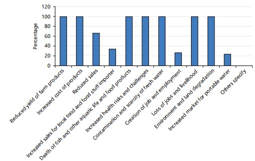
Okafor et al.21 indicated that the mangrove wetlands in Ogoniland could qualify as RAMSAR sites, provided that the damaged environments are properly rehabilitated and sustainable protection measures are established. According to Okafor and Mgbenwelu22, local residents no longer engage in subsistence fishing in the nearby creeks and rivers. Furthermore, Okafor et al.21 highlighted that the disruption of the annual “dor bon fish fencing party” in Bodo Creek since 2008, following two significant oil spills, has led to a decline in the community’s fishing knowledge, resulting in a knowledge gap that may either be permanently lost or require a substantial amount of time to restore. Okafor and Obaze24 contended that oil pollution in the Niger Delta has adversely affected the local population, leading to significant harm to their livelihoods, particularly in agriculture and fishing. This pollution increases the vulnerability of households and detrimentally affects their overall well-being. Furthermore, Okafor and Obaze24 noted that over 90% of the environmental and socio-economic degradation is concentrated in the immediate surroundings (Fig. 5).
| Table 1: | Chi-square values used in the study | |||
| DF | 0.5 | 0.1 | 0.05 | 0.02 | 0.01 | 0.001 |
| 1 | 0.455 | 2.706 | 3.841 | 5.412 | 6.635 | 10.827 |
| 2 | 1.3686 | 4.605 | 5.991 | 7.824 | 9.21 | 13.815 |
| 3 | 2.366 | 6.251 | 7.815 | 9.837 | 11.345 | 16.268 |
| 4 | 3.357 | 7.779 | 9.488 | 11.668 | 13.277 | 18.465 |
| 5 | 4.351 | 9.236 | 11.07 | 13.388 | 15.086 | 20.517 |
Statistical analysis of data using Chi-square method: Table 1 is the Chi-square chart used for the comparison of the observed and expected values in this study. The highlighted figure, 5.991, is the standard table value for the degree of freedom, which was compared with the observed value from respondents and enabled the rejection or acceptance of the null and alternative hypotheses.
The above is the Chi-square chart used for the comparison of the observed and expected values in this study. The highlighted figure, 5.991, is the standard table value for the degrees of freedom, which was compared with the observed value from respondents and enabled the rejection or acceptance of the null and alternative hypotheses.
Table 2 presents a summary of responses regarding the impacts of oil spills in Bodo, capturing both positive and negative effects. A majority of respondents acknowledged negative consequences such as loss of jobs and livelihood (96% said “Yes”), water contamination and scarcity of fresh water (100% “Yes”), land degradation and reduced farm yields (87% “Yes”), increased health risks (96% “Yes”), and death of fish and other marine life (94% “Yes”). Other negative impacts included higher transportation costs (88% “Yes”) and increased prices of farm products (89% “Yes”).
On the positive side, fewer respondents observed benefits: Only 24% agreed that oil spills led to increased sales of potable water, 34% noted higher sales for local food and foodstuff importers, and 26% agreed that there was some job creation. However, the majority did not recognize these as positive impacts, indicating that the oil spill’s effects were overwhelmingly detrimental to the Bodo community.
A random sampling of the opinions of 100 people in each of the selected towns was categorized into Yes, No, and Not Sure:
Table 3 shows the calculation of the deviation from the observed and expected values generated for the study. The total standard deviation is 1,268.7058, which is used to compare the degree of freedom value (5.991) in the Chi-square chart to enable acceptance or rejection of either hypothesis.
Statistical analysis: Using a null hypothesis statement that states that the “Impacts of oil spills observed in the study area have no direct impact on the means of livelihood of the residents of that area”, the researcher verified the argument. The statistical data below is the result of research carried out in the study area:
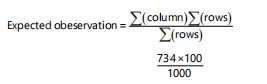 |
734 Multiplied by 100, then Divided by 1000 = 73.4
| Table 2: | Summary of responses on impacts of oil spill in Bodo | |||
| Impacts of oil spill in Bodo-positive and negative | Yes | No | No comment |
| Loss of jobs and livelihood-fishing and farmlands | 96 | 2 | 2 |
| Water contamination and scarcity of fresh water | 100 | 0 | 0 |
| Land degradation and reduced yield of farm products | 87 | 11 | 2 |
| Increased health risks and challenges | 96 | 4 | 0 |
| Death of fish and other marine food products | 94 | 4 | 2 |
| High cost of transportation | 88 | 5 | 7 |
| High cost of farm products | 89 | 10 | 1 |
| Increased sales of potable water | 24 | 76 | 0 |
| Increased sales for local food and food stuff importers | 34 | 66 | 0 |
| Creation of job and employment | 26 | 70 | 4 |
| Table 3: | Chi-square table derived from the observations in Table 2 | |||
| Observation (o) | Expected (e) | (o-e) | (o-e)2 | (o-e)2/e |
| 96 | 73.4 | 22.6 | 510.76 | 6.9586 |
| 100 | 73.4 | 26.6 | 707.56 | 9.6398 |
| 87 | 73.4 | 13.6 | 184.96 | 2.5199 |
| 96 | 73.4 | 22.6 | 510.76 | 6.9586 |
| 94 | 73.4 | 20.6 | 424.36 | 5.7815 |
| 88 | 73.4 | 14.4 | 207.36 | 2.8251 |
| 89 | 73.4 | 15.6 | 243.36 | 3.3155 |
| 24 | 73.4 | -49.4 | 2,440.36 | 33.2474 |
| 34 | 73.4 | -39.4 | 1,552.36 | 21.1493 |
| 26 | 73.4 | -47.4 | 2,246.76 | 30.6098 |
| 2 | 73.4 | -71.4 | 5,097.96 | 69.4545 |
| 0 | 73.4 | -73.4 | 5,387.56 | 73.4 |
| 11 | 73.4 | -62.4 | 3,893.76 | 53.0485 |
| 4 | 73.4 | -69.4 | 4,816.36 | 65.618 |
| 4 | 73.4 | -69.4 | 4,816.36 | 65.618 |
| 5 | 73.4 | -68.4 | 4,678.56 | 63.7406 |
| 10 | 73.4 | -63.4 | 4,019.56 | 54.7624 |
| 76 | 73.4 | 2.6 | 6.76 | 0.0921 |
| 66 | 73.4 | -7.4 | 54.76 | 0.746 |
| 70 | 73.4 | -3.4 | 11.56 | 0.1575 |
| 2 | 73.4 | -71.4 | 5,097.96 | 69.4545 |
| 0 | 73.4 | -73.4 | 5,387.56 | 73.4 |
| 2 | 73.4 | -72.4 | 5,241.76 | 69.4545 |
| 0 | 73.4 | -73.4 | 5,387.56 | 73.4 |
| 2 | 73.4 | -71.4 | 5,097.96 | 69.4545 |
| 7 | 73.4 | -66.4 | 4,408.96 | 60.0676 |
| 1 | 73.4 | -72.4 | 5,241.76 | 71.4136 |
| 0 | 73.4 | -73.4 | 5,387.56 | 73.4 |
| 0 | 73.4 | -73.4 | 5,387.56 | 73.4 |
| 4 | 73.4 | -69.4 | 4,816.36 | 65.618 |
| Total = 1,268.7058 |
Accepting the alternative hypothesis: According to the Chi-square table, the derived value χ2 = 1,268.7058 is positive and even far greater than 5.991 obtained from the Chi-square chart. Hence, based on the analysis above, the null hypothesis, “Impacts of oil spill observed in the Bodo community of the Niger Delta has no direct impact on the means of livelihood of the residents of that area”, was discarded; and the alternative, “Impacts of oil spill observed in the study area has a direct impact on the means of livelihood of the residents of that area”, was accepted.
CONCLUSION
This study found that the oil spill in the Bodo area remains a serious issue because its impacts are enormous. These include loss of lives and property, food and potable water shortages, negative impacts on health, sources of livelihood, and destruction of coastal life and ecological habitats. This study found that only a few activities are being carried out in the area in a bid to clean it up; however, these activities have never been conclusive since the years of these spills. Finally, this study found that although only a few of the inhabitants try to take advantage of the spill to better their lives, the negative impact of the spill on the majority of the inhabitants far outweighs the assumed positive impacts.
SIGNIFICANCE STATEMENT
The study evaluated the impact of the oil spill on the inhabitants of the Bodo Area of Ogoniland, Rivers State, Nigeria. The objective was to assess the effect of the oil spill on land cover changes and to examine the impacts of the oil spill as it affects the inhabitants of Bodo. The study maintained that the negative impact of the spill on the majority of the inhabitants far outweighs the assumed positive impacts.
ACKNOWLEDGMENT
Our profound appreciation goes to the almighty God for his protection, goodness, and mercy throughout the period of the study.
REFERENCES
- Adeyemo, O.K., O.A. Adedokun, R.K. Yusuf and E.A. Adeleye, 2008. Seasonal changes in physico-chemical parameters and nutrient load of river sediments in Ibadan City, Nigeria. Global Nest J., 10: 326-336.
- Etim, E.E., R. Odoh, A.U. Itodo, S.D. Umoh and U. Lawal, 2013. Water quality index for the assessment of water quality from different sources in the Niger Delta Region of Nigeria. Front. Sci., 3: 89-95.
- Mezgebe, K., A. Gebrekidan, A. Hadera and Y. Weldegebriel, 2015. Assessment of physico-chemical parameters of Tsaeda Agam River in Mekelle City, Tigray, Ethiopia. Bull. Chem. Soc. Ethiopia, 29: 377-385.
- Nkeeh, D.K., A.I. Hart, E.S. Erondu and N. Zabbey, 2021. Spatial and monthly changes in interstitial water physico-chemistry of Bodo Creek. Asian J. Fish. Aquat. Res., 15: 1-8.
- Nwipie, G.N., A.I. Hart, N. Zabbey, K. Sam, G. Prpich and P.E. Kika, 2019. Recovery of infauna macrobenthic invertebrates in oil-polluted tropical soft-bottom tidal flats: 7 years post spill. Environ. Sci. Pollut. Res., 26: 22407-22420.
- Eludoyin, O.S., A.N. Balogun and S.O. Otali, 2018. Spatial assessment of heavy metal concentrations in giant tiger shrimps (Penaeus monodon Fabricius, 1798) in Bodo Creek, Gokana LGA, Rivers State, Nigeria. Ukr. J. Ecol., 8: 340-348.
- Akubuo, F.C., L.C. Osuji and A.I. Hart, 2023. Assessment of interstitial and surface water quality of Ibaka Creek Rivers State, Nigeria: The case of artisanal refinery activities. Asian J. Fish. Aquat. Res., 25: 21-36.
- Alame, V.D., U.A. Patricia and N. Ebere, 2020. The physico-chemical parameters of Kalaigidama and Basambio creeks, Ke in Rivers State, Nigeria. Afr. J. Environ. Nat. Sci. Res., 3: 31-21.
- Zabbey, N., 2012. Spatial and temporal variability in interstitial water quality of soft-bottom flats at Bodo Creek, Eastern Lower Niger Delta, Nigeria. Trop. Freshwater Biol., 21: 83-103.
- Zabbey, N. and F.O. Arimoro, 2017. Environmental forcing of intertidal benthic macrofauna of Bodo Creek, Nigeria: Preliminary index to evaluate cleanup of Ogoniland. Reg. Stud. Mar. Sci., 16: 89-97.
- Zabbey, N. and A.I. Hart, 2014. Spatial variability of macrozoobenthic diversity on tidal flats of the Niger Delta, Nigeria: The role of substratum. Afr. J. Aquat. Sci., 39: 67-76.
- Zabbey, N. and H. Uyi, 2014. Community responses of intertidal soft-bottom macrozoobenthos to oil pollution in a tropical mangrove ecosystem, Niger Delta, Nigeria. Mar. Pollut. Bull., 82: 167-174.
- Frynas, J.G., 2005. The false developmental promise of corporate social responsibility: Evidence from multinational oil companies. Int. Aff., 81: 581-598.
- Jordan, S.J. and L.M. Smith, 2004. Indicators of Ecosystem Integrity for Estuaries. In: Estuarine Indicators, Bortone, S.A. (Ed.), CRC Press, Florida, United States, ISBN: 9780429122231, pp: 467-480.
- Kotta, J., G. Martin and R. Aps, 2007. Sensitivity of benthic vegetation and invertebrate functional guilds to oil spills and its use in oil contingency management related negotiation processes. Est. J. Ecol., 56: 255-269.
- Plater, Z.J.B., 2010. Learning from disasters: Twenty-one years after the Exxon Valdez oil spill, will reactions to the Deepwater Horizon Blowout finally address the systemic flaws revealed in Alaska? Environ. Law Rep., 40: 1041-1047.
- Rönnbäck, P. 1999. The ecological basis for economic value of seafood production supported by mangrove ecosystems. Ecol. Econ., 29: 235-252.
- Edori, O.S., W.A. Iyama and M.Q.C. Amadi, 2020. Variation of some physicochemical parameters in surface water of Elelenwo River, Rivers State, Niger Delta, Nigeria. Int. J. Res. Sci. Innovation, 7: 230-235.
- Sathirathai, S. and E.B. Barbier, 2001. Valuing mangrove conservation in Southern Thailand. Contemp. Econ. Policy, 19: 109-122.
- Zabbey, N. and A.I. Hart, 2011. Preliminary checklist of macrozoobenthos of Bodo Creek in the Niger Delta, Nigeria. Niger. J. Fish., 8: 272-283.
- Okafor, O.C., W.O. Obaze, C. Njoku and S.C. Udenze, 2023. Effect of waste disposal sites on physicochemical properties of water in selected states of Southeast Nigeria. Environ. Monit. Assess., 195.
- Okafor, O.C. and P.O. Mgbenwelu, 2023. Urban agriculture impacts on the environment of Awka, Anambra State, Southeastern Nigeria. Trends Agric. Sci., 2: 44-53.
- Vincent-Akpu, I.F., A.N. Tyler, C. Wilson and G. Mackinnon, 2015. Assessment of physico-chemical properties and metal contents of water and sediments of Bodo Creek, Niger Delta, Nigeria. Toxicol. Environ. Chem., 97: 135-144.
- Okafor, O.C. and W.O. Obaze, 2025. Assessment of heavy metal contents of surface water around waste dumpsites in Ebonyi, Enugu and Anambra States, Southeastern Nigeria. Environ. Forensics.
How to Cite this paper?
APA-7 Style
Okafor,
O.C., Ibeneme,
P.A. (2025). Impact of Oil Spill on the Inhabitants of Bodo Area of Ogoni Land, River State, Nigeria. Trends in Environmental Sciences, 1(2), 208-218. https://doi.org/10.21124/tes.2025.208.218
ACS Style
Okafor,
O.C.; Ibeneme,
P.A. Impact of Oil Spill on the Inhabitants of Bodo Area of Ogoni Land, River State, Nigeria. Trends Env. Sci 2025, 1, 208-218. https://doi.org/10.21124/tes.2025.208.218
AMA Style
Okafor
OC, Ibeneme
PA. Impact of Oil Spill on the Inhabitants of Bodo Area of Ogoni Land, River State, Nigeria. Trends in Environmental Sciences. 2025; 1(2): 208-218. https://doi.org/10.21124/tes.2025.208.218
Chicago/Turabian Style
Okafor, Odera, Chukwumaijem, and Patience Afor Ibeneme.
2025. "Impact of Oil Spill on the Inhabitants of Bodo Area of Ogoni Land, River State, Nigeria" Trends in Environmental Sciences 1, no. 2: 208-218. https://doi.org/10.21124/tes.2025.208.218

This work is licensed under a Creative Commons Attribution 4.0 International License.